


xc 200516 hohwald

xc
User
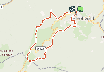

Length
9.3 km

Max alt
781 m

Uphill gradient
238 m
Km-Effort
12.5 km

Min alt
586 m

Downhill gradient
240 m
Boucle
Yes
Creation date :
2020-05-16 08:59:34.899
Updated on :
2020-05-21 12:37:46.328
4h29
Difficulty : Very easy

FREE GPS app for hiking
 SityTrail
IGN / Geographical institutes
SityTrail Plus
The world is yours!
About
Trail Walking of 9.3 km to be discovered at Grand Est, Bas-Rhin, Le Hohwald. This trail is proposed by xc.
Positioning
Country:
France
Region :
Grand Est
Department/Province :
Bas-Rhin
Municipality :
Le Hohwald
Location:
Unknown
Start:(Dec)
Start:(UTM)
375903 ; 5362671 (32U) N.
Comments